Last updated: March 2026 · By the local guides at BlueCat Properties, Indian Pointe Resort, Osage Beach, MO
Quick Summary: This guide covers 15 of the best hiking and biking trails near Lake of the Ozarks and Osage Beach, Missouri — organized by three areas: Ha Ha Tonka State Park (6 trails, including the famous Castle Trail and Devil's Kitchen), Lake of the Ozarks State Park (5 trails with lake bluff views), and 3 other nearby trails including a section of the 240-mile Katy Trail. Trail distances range from 0.8 miles (Castle Trail) to 6.9 miles (Turkey Pen Hollow). Most are rated easy to moderate. A bonus section covers the historic Swinging Bridges near Brumley. All trails are within 10–30 minutes of Indian Pointe Resort.
In This Guide:
-
Ha Ha Tonka State Park Trails (6 trails)
-
Lake of the Ozarks State Park Trails (5 trails)
-
Other Nearby Trails (3 trails)
-
Trail Comparison Table
-
Bonus: Swinging Bridges of the Ozarks
-
Frequently Asked Questions
The Lake of the Ozarks and Osage Beach offer a stunning blend of natural beauty and outdoor adventure. Whether you're a seasoned hiker or a casual biker, there's a trail waiting to be explored. Lace up your boots or grab your bike and get ready to discover these 15 gems, all starting from a convenient location at Indian Pointe, Osage Beach, MO:
Ha Ha Tonka State Park:
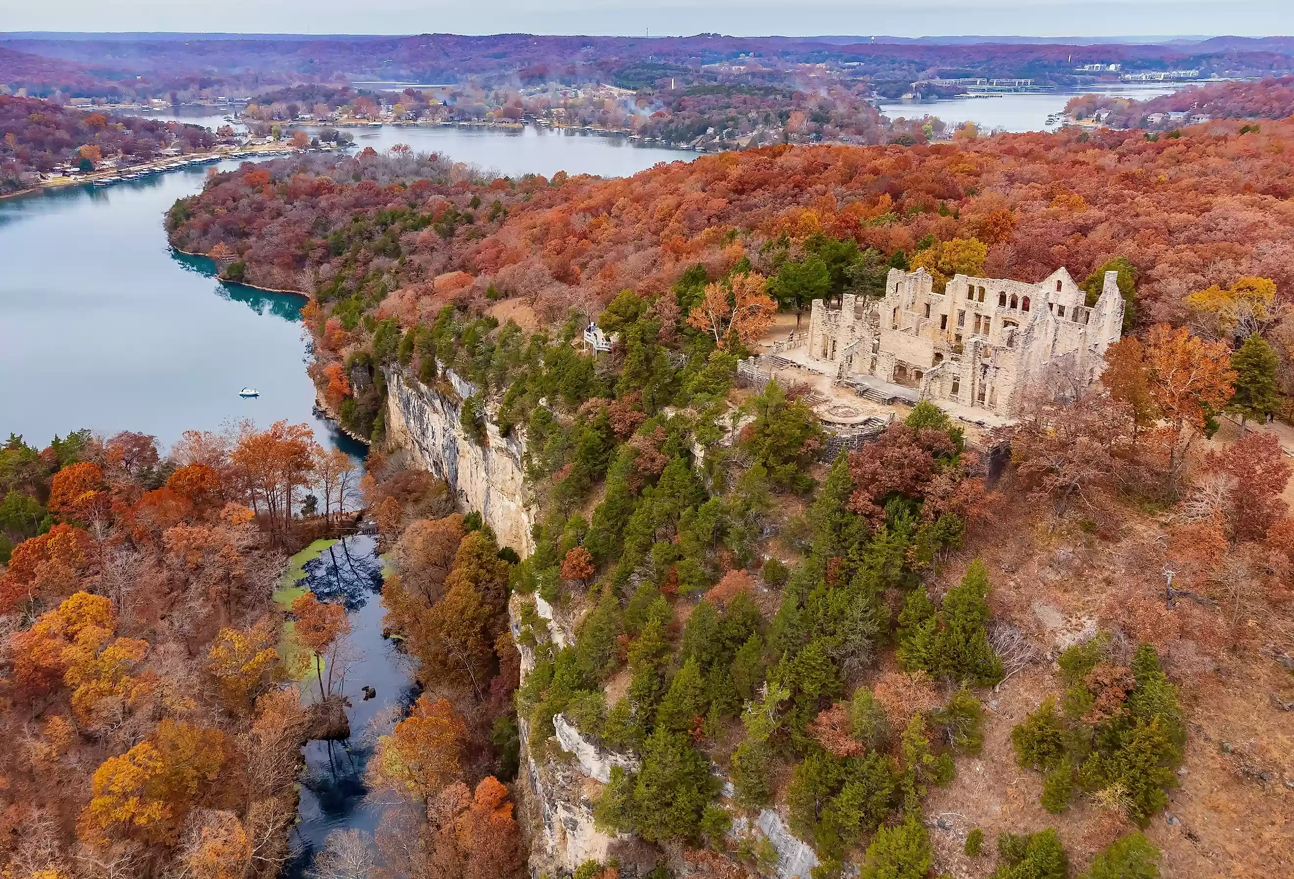
For explorers, hikers, and sightseers, Ha Ha Tonka State Park is an absolute must-visit. With its fascinating history and stunning natural beauty, it's no wonder it's a favorite among locals and visitors alike. Whether you arrive by boat or car, you'll be captivated by the majestic castle ruins and breathtaking views.
-
Devil's Kitchen Trail Loop (Easy, 1.3 miles, 43 min, 121 ft elevation change):
This short, family-friendly loop winds through a scenic valley, offering glimpses of the Niangua Arm of the lake. Perfect for a leisurely stroll or a quick escape into nature. The Devil's Kitchen is a natural-surface loop trail that takes you through dry chert woodland and glades before entering the Devil's Kitchen sinkhole, a small cave shelter. [info] [directions]. -
Tonka Quarry Trail Green Loop (Moderate, 2.9 miles, 367 ft elevation change):
Quarry Trail takes visitors through two quarry sites, where sandstone was mined to build the castle, carriage house, and water tower. At the trailhead near the castle ruins, the trail passes next to the site where 10 greenhouses were constructed as part of the Robert Snyder estate. The greenhouses were removed and sold after Snyder's death, but the foundations and interpretive panel remain at the site. [info] -
Turkey Pen Hollow Trail (Moderate, 6.9 miles, 700 ft elevation change):
Immerse yourself in the Ozark woodlands on this moderate trail. Expect some elevation changes and rocky sections, rewarded by stunning panoramic views of the surrounding hills. This trail passes through high-quality dolomite glades and woodland plant communities. The trail passes by a giant sinkhole, the access to the park's special-use camp, a primitive backpacking area for large groups, and Turkey Pen Hollow. [info] -
Castle Trail (Easy, .8 miles, 300 ft elevation change):
The Castle Trail is a family-friendly trail leading to castle ruins and a lake overlook. The stunning views make Castle Trail one of the park's most popular trails. Construction of the mansion began in 1905 by a businessman from Kansas City, but it burned down in the 1940s, leaving only ruins. [info]. -
Spring Trail (Moderate, 1.4 miles, 200 ft elevation change):
Check out this 1.4-mile loop trail near Camdenton, Missouri. Generally considered a moderately challenging route, it takes an average of 37 min to complete. This is a very popular area for birding, camping, and hiking, so you'll likely encounter other people while exploring. The trail is open year-round and is beautiful to visit anytime. Dogs are welcome, but must be on a leash.[info]. -
Ha Ha Tonka Island Trail (Moderate, .9 miles, 229 ft elevation change):
The Island trailhead is the old mill site, accessible from the Spring Trail. This is a rugged loop with scenic rock formations, a small cave, and spring views. Explore this 0.9-mile out-and-back trail near Camdenton, Missouri. Generally considered a moderately challenging route, it takes an average of 30 min to complete. This is a very popular area for birding, hiking, and running, so you'll likely encounter other people while exploring. The trail is open year-round and is beautiful to visit anytime. Dogs are welcome, but must be on a leash. [info].

Directions from BlueCat Properties

Lake of the Ozarks State Park:
-
Hidden Springs Trail (Moderate, 2.4 miles, 278 ft elevation change):
Blazed in Green. The Hidden Spring Trail goes through native Missouri woodlands to bluff tops above the lake. Depending on the season, users may see flowering dogwoods or hear pileated woodpeckers. In addition to the abundant natural history in this area, the trail also passes near a small family cemetery. [info] -
Rocky Top Trail (Moderate, 4.6 miles, 500 ft elevation change):
Rocky Top Trail is blazed in Red. This popular trail climbs to one of the largest glades in the park. Historically influenced by periodic fires, these dolomite glades are becoming rare as cedars encroach and choke out the native vegetation. Rocky Top Glade is now managed with periodic fires to help restore and maintain its natural integrity. The trail crosses through a ravine and reaches a rich north-facing slope that gives way to dolomite cliffs overlooking the Lake of the Ozarks. [info] -
Trail of the Four Winds Loop - North Loop (Moderate, 4.2 miles, 291 ft elevation change):
This scenic loop at Lake of the Ozarks State Park traverses rolling hills and forests, with glimpses of the lake throughout. Trail of the Four Winds - North Loop in Brumley, Missouri, offers a typical walk through the woods with some muddy and fun sections, ankle-deep water crossings, and beautiful scenery. Recent reviews mention multiple water crossings, muddy areas, and the need for shoes that can get wet. [info] -
Fawn's Ridge Trail (Moderate, 1.3 miles, 164 ft elevation change):
Fawn's Ridge Trail is blazed in Yellow. Try this 1.3-mile loop trail near Linn Creek, Missouri. Generally considered a moderately challenging route, it takes an average of 33 min to complete. This trail is great for camping, hiking, and walking, and it's unlikely you'll encounter many other people while exploring. The trail is open year-round and is beautiful to visit anytime. Dogs are welcome, but must be on a leash.[info]. -
Lakeview Bend Trail (Moderate, 1.5 miles, 157 ft elevation change):
Enjoy a picturesque loop along the shoreline, offering stunning lake vistas and abundant birdwatching opportunities. Lakeview Bend Trail is blazed in Blue. Lakeview Bend Trail follows towering bluffs and gentle slopes through Ozark woodlands to panoramic lake views. Native columbines and ferns are common on the trail. Hikers often see white-tailed deer and fox squirrels. [info]
Lake of the Ozarks State Park Info
Directions from BlueCat Properties
Other Nearby Trails:
-
Shady Ridge Trail (Easy, 2 miles, 150 ft elevation change):
This scenic trail traverses rolling hills and woodlands, providing a peaceful escape from the hustle and bustle. Located near Osage Beach within LOTO West Community Park [Info and directions]. -
Katy Trail State Park (Varies in difficulty, elevation change, and length):
Embark on an epic cycling adventure on this long-distance rail trail. Choose a section that suits your experience level, with portions accessible from nearby Eldon or Jefferson City. Find information and access points at [Katy Trail State Park website]. -
Jefferson City Greenway Trail (Varies in difficulty, elevation change, and length):
Explore the city of Jefferson City on this scenic paved trail. Enjoy a leisurely ride or incorporate it into a longer cycling adventure. Find information and access points at [Jefferson City Greenway Trail website].
This expanded list offers a variety of options for all skill levels, allowing you to choose the perfect trail for your next outdoor adventure in the Lake of the Ozarks region. Remember to check trail conditions before you go, pack accordingly, and let someone know your plans. Happy hiking and biking!
Trail Comparison: At a Glance
| Trail Name | Park / Area | Difficulty | Distance | Elevation Δ | Dogs OK? |
|---|---|---|---|---|---|
| Devil's Kitchen Trail Loop | Ha Ha Tonka SP | Easy | 1.3 mi | 121 ft | Yes (leash) |
| Tonka Quarry Trail Green Loop | Ha Ha Tonka SP | Moderate | 2.9 mi | 367 ft | Yes (leash) |
| Turkey Pen Hollow Trail | Ha Ha Tonka SP | Moderate | 6.9 mi | 700 ft | Yes (leash) |
| Castle Trail | Ha Ha Tonka SP | Easy | 0.8 mi | 300 ft | Yes (leash) |
| Spring Trail | Ha Ha Tonka SP | Moderate | 1.4 mi | 200 ft | Yes (leash) |
| Island Trail | Ha Ha Tonka SP | Moderate | 0.9 mi | 229 ft | Yes (leash) |
| Hidden Springs Trail | LOTO State Park | Moderate | 2.4 mi | 278 ft | Yes (leash) |
| Rocky Top Trail | LOTO State Park | Moderate | 4.6 mi | 500 ft | Yes (leash) |
| Trail of the Four Winds — North Loop | LOTO State Park | Moderate | 4.2 mi | 291 ft | Yes (leash) |
| Fawn's Ridge Trail | LOTO State Park | Moderate | 1.3 mi | 164 ft | Yes (leash) |
| Lakeview Bend Trail | LOTO State Park | Moderate | 1.5 mi | 157 ft | Yes (leash) |
| Shady Ridge Trail | Osage Beach (LOTO West) | Easy | 2.0 mi | 150 ft | Yes |
| Katy Trail State Park | Eldon / Jefferson City | Varies | 240 mi total | Varies | Yes |
| Jefferson City Greenway Trail | Jefferson City | Varies | Varies | Varies | Yes |
Bonus Insider Insight.
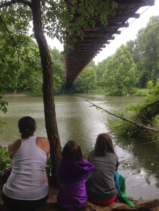
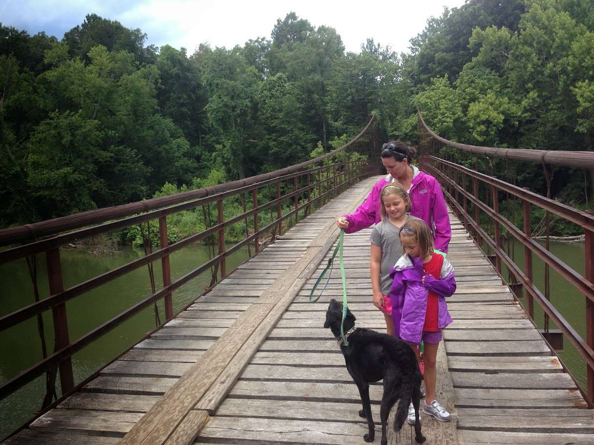
Dual Swinging Bridges - Grand Auglaize Bridge and Mill Creek Swinging Bridge -
Swinging Bridges of the Ozarks: Where History and Adventure Collide
Seeking a unique blend of scenic beauty and heart-pounding thrills on your Lake of the Ozarks getaway? Look no further than the iconic Swinging Bridges, a must-visit destination for couples seeking a romantic drive, families craving outdoor fun, or anyone with an adventurous spirit.
Grand Auglaize Bridge: A Historic Marvel
The Grand Auglaize Bridge, affectionately known as the "Big Swinging Bridge," is a testament to engineering ingenuity and a treasured piece of local history. Built around 1930-31, this 500-foot wired cable suspension bridge once gracefully spanned the Grand Auglaize Creek southwest of Brumley. While currently closed to traffic for restoration, its majestic silhouette remains a sight to behold. Stay tuned for its grand reopening, anticipated in 2025 or 2026, when it will once again welcome visitors to traverse its thrilling expanse.
Mill Creek Bridge: A Hidden Gem
For a taste of the swinging bridge experience, venture to the Mill Creek Bridge, a charming 135-foot wire suspension bridge that dances across Mill Creek. This secluded spot, accessible via Swinging Bridges Road, is a perfect place for a picnic, a leisurely stroll, or a refreshing dip in the creek on a warm day.
Fall Fun at the Cave Pumplin Patch
If your visit coincides with October, don't miss the Cave Pumplin Patch, a lively fall festival brimming with family-friendly activities. Located conveniently on Swinging Bridges Road, it's a delightful detour to add to your itinerary.
Plan Your Visit
Whether you're exploring the area's rich history, chasing thrills on the swinging bridges, or simply enjoying the serenity of nature, this unique destination promises an unforgettable experience. Just a short 20-minute drive from BlueCat Properties' vacation rentals, it's the perfect addition to your Lake of the Ozarks adventure. [Directions]